In this post, we continue reviewing the development of the building as shown by the walls uncovered during the archaeology. This one looks at the building of St Mary’s Chapel. As with most of the early work there is insufficient written information to say when the work took place. It is known that from the early 15th century, plans were being made for the expansion of the relatively small main church to create a cathedral-sized building. However, this was hampered by the lie of the land. The existing building was on the top a small hill, with the ground sloping away gradually to the south towards the harbour and to the north towards the Loch. To the west was the Denburn valley and immediately to the east the fairly steep slopes of the Putachie Burn. Some idea of the latter can be seen today in the form of the steps down from the Kirkyard to the top of Correction Wynd.
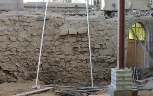
In order to facilitate the expansion to the east a separate building was erected. This was a chantry chapel, now known as St Mary’s Chapel, which would act as an undercroft to allow the expansion of the church building above it at a later date. During the archaeological dig the west wall of the Chapel was uncovered and is shown as it is today in the photograph. The exact date of building the Chapel is not known, but it was probably around the 1440s. At the time it was erected St Mary’s Chapel was a completely separate building in the burial ground, about 10 feet to the east of the existing church building. There were burials in the ground between the two buildings and the west wall of St Mary’s Chapel was actually built on top of some of the burials.

There are two doorways through the wall which would have allowed access to the expanded building above – one can be seen in the photograph to the right, with a light in the Chapel showing through. One doorway lead to a stairway, part of which still remains. The other may have had a stair, but there is also evidence that there was some sort of sloping path or ramp (this will feature in a later blog). The wall itself has various features, the most obvious of which can be seen in the centre of the photograph, namely the protruding stones. It is assumed that these were built like this to allow the expanded church building to key into the wall. They would have acted as the springer, or lowest voussoir, of the arches supporting the floor of the expanded church later in the century. The top of the wall in the photograph was at the floor level of the former East Kirk. The soil which can be seen is at the ground level of Aberdeen a millennium ago. The vertical steel beam to the right is part of the temporary supports for the gallery above.